DarjeelingHIMALAYAS
Sandakphu

Sandakphu & the Singalila Ridge · viewpoint

Sandakphu

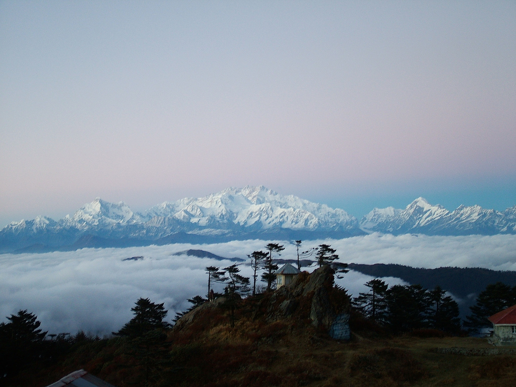
West Bengal's highest point, with Everest on the skyline

Altitude3,636m Nights1–2 BestApr · Oct – Dec

Photo: solarshakti · CC BY 2.0, Wikimedia Commons

In brief

Sandakphu, at 3,636 m on the India–Nepal border, is the highest point in West Bengal. From its summit four of the world's five highest peaks, Everest, Kanchenjunga, Lhotse and Makalu, are visible on clear mornings, with the Kanchenjunga range forming the Sleeping Buddha. Reach it in 3–4 days on foot or 4 hours by Land Rover.

The local story

The height of the poisonous plant

Sandakphu's name is usually traced to Lepcha and translated as 'the height of the poisonous plant'. A century ago the summit slopes were thick with aconite, Aconitum ferox, one of the most toxic plants known, along with rhododendrons poisonous to livestock. Herders driving sheep and cattle along the ridge are said to have muzzled them here so they could not graze. The aconite is much rarer now, but the name stuck, and so did Bikheybhanjang, the 'poison pass' below.

For the British in Darjeeling, the ridge became a classic hill excursion for the view of Everest, which the Survey of India announced as the world's highest peak in 1856. In 1905 the first documented Kanchenjunga expedition passed this way. Today a small settlement sits on the summit, with a GTA trekkers' hut, family lodges, and an SSB border camp, and the cobbled track brings Land Rovers from Maneybhanjan almost every day of the open season.

Sandakphu at 3,636 m is the highest point in West Bengal; Phalut, 21 km north along the ridge at about 3,600 m, is the second highest.
From the summit, Kanchenjunga lies roughly 70 km to the north while Everest is about 140 km away to the north-west.
K2 is the only one of the world's five highest peaks not visible from Sandakphu; it stands in the Karakoram, about 1,500 km to the north-west.

About Sandakphu

Sandakphu is a bald, windswept summit with a cluster of lodges, a trekkers' hut, prayer flags and an army-green SSB camp, and from it you see more of the high Himalaya than from almost anywhere you can reach without a tent. To the north, the Kanchenjunga massif spreads across the horizon with its neighbours Kabru, Pandim and Simvo. To the north-west, beyond the hills of Nepal, the Everest group stands in a tight cluster, with Lhotse beside it and Makalu's dark pyramid to the right.

Most people arrive tired, either after three days of walking or four hours of bouncing in a Land Rover, and the summit can be in cloud on arrival. Do not worry. The mountains usually show at sunset or at dawn. Sleep here at least one night, get up at 5 am, and stand at the viewpoint as the Sleeping Buddha turns pink. This is the moment the whole trip is built around.

What to see and do

The Sleeping Buddha at dawn

The Kanchenjunga massif and its neighbouring peaks form a long reclining outline that guides call the Sleeping Buddha. At sunrise the summits turn pink, then gold, while the valleys stay dark. On clear days it fills about a third of the horizon.

Everest, Lhotse and Makalu

Look north-west for a tight group of peaks beyond the Nepali hills: Everest, with Lhotse beside it and Makalu's sharp pyramid to the right. They are 125–145 km away, small but unmistakable on clear autumn mornings.

Highest point in West Bengal

Standing at 3,636 m, you are on the state's highest ground, on a ridge that marks the international border. Prayer flags, a survey marker and the SSB camp share the summit.

The Land Rover arrival

Watching the old Land Rovers from Maneybhanjan crawl up the last switchbacks to the summit is part of the scene. If you rode up, you will remember the final stretch, cobbled, steep and full of hairpins.

Rhododendron and aconite slopes

In April and May the slopes below the summit flower with rhododendrons, and in late summer the aconite that gave Sandakphu its name blooms blue and purple. The park closes in the monsoon, so the aconite is rarely seen by trekkers.

Gateway to Phalut

Sandakphu is the turning point. Most trekkers go down to Srikhola and Rimbik from here, but the 21 km ridge walk north to Phalut, with Kanchenjunga ahead all day, is the finest stretch of the whole trail.

How to get there

On foot
From Maneybhanjan via Chitrey, Tumling, Gairibas and Kalipokhri: about 31 km over 3 days, gaining around 1,500 m. Alternatively, start from Dhotrey via Tonglu. A licensed guide and park entry are required.
Land Rover
From the Maneybhanjan stand, about 4 hours on the cobbled track. Indicatively ₹6,500–9,000 a vehicle for a round trip with one night, up to six passengers, plus guide fee. Check current status before you travel.
On foot from Srikhola
The steep reverse route up from Srikhola via Gurdum climbs about 1,700 m in roughly 13 km. It is hard work and usually done downhill instead.

Where to stay

Sandakphu has a GTA trekkers' hut and a group of private lodges along the summit, including Sherpa Chalet, one of the longest-running. Rooms range from dorm beds at about ₹500–900 per person to private twins at ₹2,000–3,500, with meals extra. Toilets are mostly shared and cold. Book ahead for October, the Puja holidays, Christmas and April weekends; at other times beds are easier, but phone ahead through your guide.

Local tips

  • Stay two nights if you can; a second dawn doubles your chance of a clear Everest view.
  • Watch sunset as well as sunrise; Makalu and Everest often glow pink after the afternoon cloud clears.
  • Sleep in a cap and warm socks; rooms are unheated and nights drop well below freezing in winter.
  • Drink plenty of water and avoid alcohol; 3,636 m is high enough for headaches.
  • Pay attention to your guide on the summit's edges; the border and SSB areas are not for wandering.

On the map

Sandakphu and its neighbours

Map of Sandakphu, Kalipokhri, Phalut, Srikhola, TumlingIndiaChinaNepalSandakphu1SandakphuKalipokhri2KalipokhriPhalut3PhalutSrikhola4SrikholaTumling5Tumling10 kmN
  1. 1Sandakphu
  2. 2Kalipokhri
  3. 3Phalut
  4. 4Srikhola
  5. 5Tumling
Drawn by Darjeeling Himalayas from Natural Earth outlines (public domain). Borders as depicted by India. Not for navigation.

Close by

Nearby places

Kalipokhri
trek stop3,186 m Kalipokhriकालीपोखरी The black pond on the border, an hour below Sandakphu
Phalut
viewpoint3,600 m Phalut Where India, Nepal and Sikkim meet under Kanchenjunga
river town1,900 m Srikhola A riverside lodge stop where the trail meets the road
Tumling
trek stop2,970 m Tumling A Nepali hamlet with the first big Kanchenjunga dawn

Routes

Ways to travel

Questions people ask

Questions about Sandakphu

Is Sandakphu the highest point in West Bengal?

Yes. At 3,636 m, Sandakphu is the highest point in West Bengal and the highest summit of the Singalila Ridge. Phalut, about 21 km north, at around 3,600 m, is the second highest. Both lie on the India–Nepal border.

Can you see Everest from Sandakphu?

Yes, on clear days, along with Lhotse and Makalu, about 125–145 km to the north-west. Kanchenjunga dominates the northern view. October to December gives the best chances; dawn is the most reliable time.

How do I reach Sandakphu?

Walk from Maneybhanjan in 3 days via Tumling, Gairibas and Kalipokhri, or ride a Land Rover from Maneybhanjan in about 4 hours. Both need park entry and a licensed guide. Maneybhanjan is 26 km from Darjeeling.

What is the best time to visit Sandakphu?

October to December for clear mountain views, with November often the best month. April and May bring rhododendrons but haze. January and February bring snow and very clear but cold days. The park usually closes mid-June to mid-September.

Does it snow at Sandakphu?

Yes, most winters, mainly from late December to February and sometimes in March. Snow can close the Land Rover track and make walking slow. Snowfall is not guaranteed on any given date.

Where can I stay in Sandakphu?

At the GTA trekkers' hut or private lodges such as Sherpa Chalet. Expect dorm beds at about ₹500–900 per person or private twins at ₹2,000–3,500, all basic and unheated. Book ahead in peak season.

How cold does it get at Sandakphu?

In December and January nights drop to about −8 to −10 °C, sometimes colder with wind. October and November nights are around −2 to 3 °C. Even in May, nights are near 4–6 °C. Carry serious warm layers.

Is Sandakphu suitable for children and older people?

By Land Rover, generally yes for healthy travellers, though the altitude of 3,636 m and the rough ride need care. Children should be watched for altitude symptoms. People with heart or lung conditions should consult a doctor first.

Is there electricity and network at Sandakphu?

Electricity is available but can be intermittent; carry a power bank. Indian and Nepali mobile networks reach the summit patchily. Turn off data roaming to avoid charges on Nepali networks.

Plan with a local

Tell us your dates. We send the real cost

Where you want to go, how many of you, and roughly what you want to spend a day. A planner who lives in these hills replies within one working day with a route and every rupee written down.

  • No payment to start
  • Shared jeep or private car, your choice
  • Homestays we have slept in
  • Change anything, any time before you book

Get a priced route

Within one working day. No payment to start.

We reply by email or WhatsApp. See our privacy policy.

Plan Sandakphu